|
|
EVALUATION OF AVAILABLE SIGHT DISTANCE IN HIGHWAYS USING GEOGRAPHIC
INFORMATION SYSTEMS (VISCASIG) |
|

MASTER THESES
|
DEVELOPMENT OF SOFTWARE FOR SIGHT DISTANCE STUDIES
OF HIGHWAYS. APPLICATION TO HIGHWAY M607 (SPAIN). |
|
QUANTITATIVE METHODS FOR THE ANALYSIS OF HIGHWAY
ALIGNMENT COORDINATION. |
|
INFLUENCE OF DIGITAL TERRAIN MODEL FEATURES ON
AVAILABLE SIGHT DISTANCE ESTIMATION OF HIGHWAYS |
|
|
|
|
|
|
|
End-of-degree
Project carried out by José Antonio Anta Viguera. Geodesic and
Carthographyc Engineering Postgraduate Degree. Technical University
of Madrid (UPM) |
|
End-of-Master
Thesis carried out by César de Santos Berbel. Master’s Degree Program
on Civil Engineering Systems. Technical
University of Madrid (UPM) |
|
End-of-Master
Thesis carried out by Álvaro García-Espona García. Master’s Degree
Program on Civil Engineering Systems. Technical
University of Madrid (UPM) |
DOCTORAL DISSERTATIONS
|
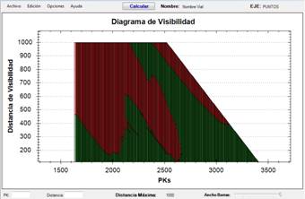
De Santos Berbel, C. (2017). "Metodología para el análisis de la distancia de visibilidad disponible en carreteras, la coordinación del trazado y su relación con la seguridad vial" ("A methodology for sight distance analysis on highways, alignment coordination, and their relation to traffic safety). Doctorado en Sistemas de Ingeniería Civil (DOSIC). ETSI Caminos, Canales y Puertos. Universidad Politécnica de Madrid. (pdf 1) (pdf 2) |